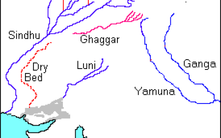

East Flowing Rivers
East Flowing- General River Nature
East Flowing- General River Nature

- flow into the Bay of Bengal
- have many tributaries
- forms Deltas
- carry larger sediments than West flowing rivers.
Mahanadi
- The river Mahanadi originates near Sihawa in Raipur district of Chattisgarh and flows through Odisha.
- Its length is 851 km.
- Major tributaries: Seonath, Hasdeo, Mand, Ib, Jonking and Telen, Sandur rivers.
- The main stream of Mahanadi gets divided into several distributaries such as Paika, Birupa, Chitartala, Genguti, and Nun.
- All these distributaries form the Delta of Mahanadi which is one of the largest deltas in India.
- The Mahanadi empties its water in Bay of Bengal.
Godavari
- Godavari is the longest river (1,465 km) among the Peninsular rivers with an area of 3.13 lakh km².
- It is also called Vridha Ganga.
- It originates in Nasik district of Maharashtra, a portion of Western Ghats.
- It flows through the states of Telangana and Andhra Pradesh before joining Bay of Bengal.
- Purna, Penganga, Pranitha, Indravati, Tal, and Salami are its major tributaries.
- The river near Rajahmundry gets divided into two channels called Vasistha and Gautami and forms one of the largest deltas in India.
- Kolleru, a freshwater lake, is located in the deltaic region of the Godavari.
Krishna
- The river Krishna originates from a spring at a place called Mahabaleshwar in the Western Ghats of Maharashtra.
- Its length is 1,400 km and an area of 2.58 lakh sq km.
- It is the second longest Peninsular river.
- Bhima, Peddavagu, Musi, Koyna, and Thungabhadra are the major tributaries of this river.
- It also flows through Andhra Pradesh and joins in Bay of Bengal at Hamasaladeevi.
Kaveri
- The river Kaveri originates at Talakaveri, Kudagu hills of Karnataka.
- Its length is 805 km.
- The river Kaveri is called Dhakshin Ganga or Ganga of the south.
- In Karnataka, the river bifurcates twice, forming islands of Srirangapatnam and Sivasamudram.
- While entering Tamil Nadu, the Kaveri continues through a series of twisted wild gorges until it reaches Hogenakkal Falls and flows through a straight, narrow gorge near Salem.
- The Kaveri breaks at Srirangam Island with two channels, river Coleroon and Kaveri.
- At last, it empties into the Bay of Bengal at Poompuhar.
- Tributaries of the Cauvery River
Left Bank: the Harangi, the Hemavati, the Shimsha, and the Arkavati.
Right Bank: Lakshmantirtha, the Kabbani (Kabini river), the Suvarnavati, the Bhavani, the Noyil, and the Amaravati joins from the right.
Penna/Penner River
- Penna/Penner rises on the Nandi Hills in the Chikkaballapur district of Karnataka, passing north to east through Karnataka and Andhra Pradesh.
- The Penna rises in the Chenna Kesava hill of the Nandidurg range, in the Chikkaballapura district of Karnataka, and flows towards the east eventually draining into the Bay of Bengal.
- The total length of the river from its origin to its outfall in the Bay of Bengal is 597 km.
- Located in peninsular India, the Pennar basin extends over the states of Andhra Pradesh and Karnataka having an area of 55 thousand sq.km.
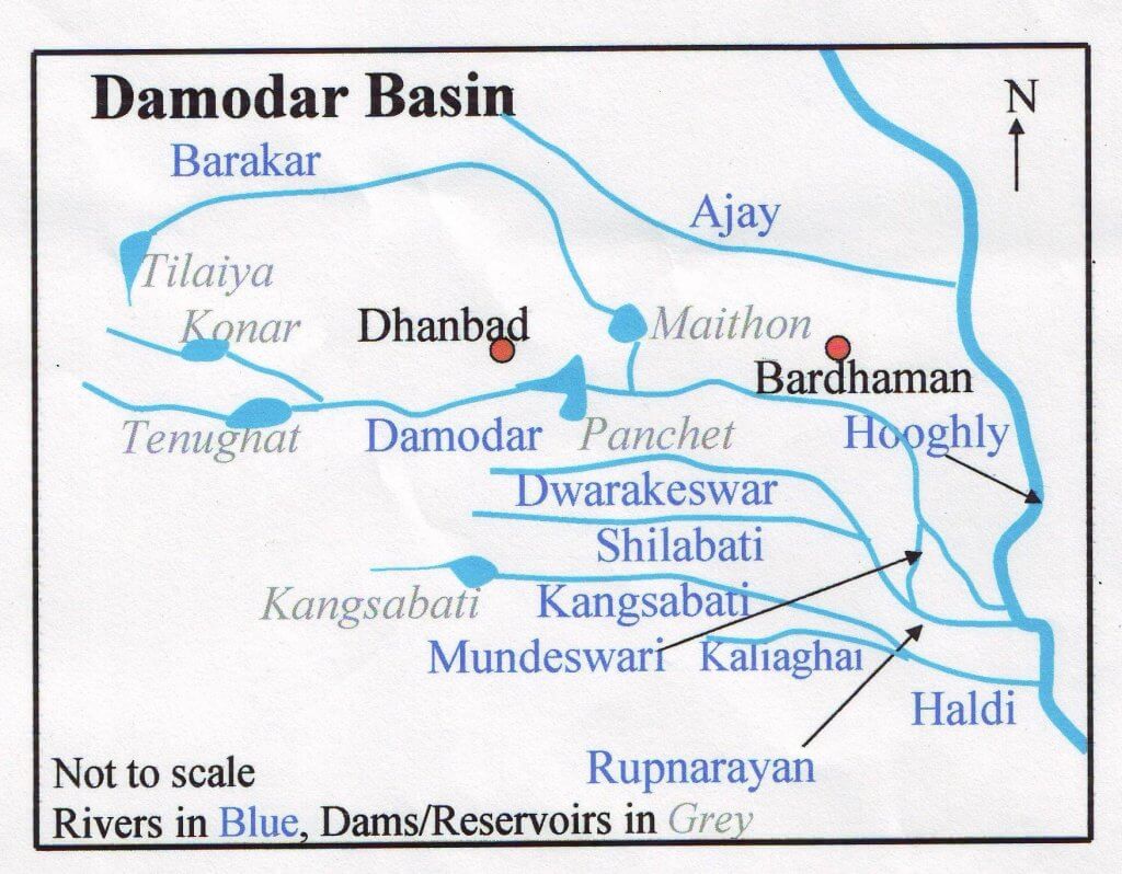
Damodar River
- The Damodar River rises in the Palamau hills of Chota Nagpur at an elevation of about 609.75 m and flows through a rift valley.
- It flows in a south-easterly direction entering the deltaic plains below Raniganj. Near Burdwan, the river abruptly changes its course to a southerly direction and joins Hooghly about 48.27 km below Calcutta.
- It has a number of tributaries and subtributaries, such as Barakar, Konar, Bokaro, Haharo, Jamunia, Ghari, Guaia, Khadia and Bhera.
- The biggest tributary of the Damodar River is the Barakar. The source of Barakar is located in the vicinity of the Padma in the Hazaribagh district.
- Earlier known as the Sorrow of Bengal because of its ravaging floods in the plains of West Bengal.
- At present, the Damodar is the most contaminated river in India, due to the various industries that have mushroomed on its riverbanks, which are good resources of minerals. There are a number of coal-oriented industries that are scattered over the Damodar basin.
Palar River
- Palar is a river of southern India. It rises in the Nandi Hills in Chikkaballapura district of Karnataka state and flows in Karnataka, Andhra Pradesh, and Tamil Nadu before reaching its confluence into the Bay of Bengal at Vayalur.
- The Cheyyar and the Ponnai in Tamil Nadu are the major tributaries of this river Palar.
- Palar river water from Palar anicut is diverted to the Poondi reservoir located in the Kosasthalaiyar River basin and to Chembarambakkam Lake located in the Adayar River basin.
Subarnarekha River
- The Subarnarekha originates from the Ranchi Plateau in Jharkhand forming the boundary between West Bengal and Odisha in its lower course.
- It joins the Bay of Bengal forming an estuary between the Ganga and Mahanadi deltas. Its total length is 395 km.
- Left bank: Dulang River
- Right bank: Kanchi River, Kharkai, Karkari River, Raru River, Garru River
- Hundru Falls is created on the course of the Subarnarekha, where it falls from a height of 98 metres (322 ft).
Brahamani River
- The Brahmani river comes into existence by the confluence of the Koel and the Sankh rivers near Rourkela. It has a total length of 800 km.
- The basin is bounded in the North by the Chhotanagpur plateau, in the West and South by the Mahanadi basin, and in the East by the Bay of Bengal.
- The basin flows through Jharkhand, Chhattisgarh, and the Orissa States and drains into the Bay of Bengal.
- Together with the river Baitarani, it forms a large delta before emptying into the Bay of Bengal at Dhamra.
Baitarni River
- The Baitarani River is one of the major rivers of Orissa.
- The basin lies mostly in the State of Orissa excluding 736 km2 in Singhbhum District of Jharkhand State.
- The Baitarani River originates from Guptaganga hills in Keonjhar District of Orissa.
- Initially the river flows in northern direction for about 80 km and then takes a sudden right turn. In this reach, the river serves as a boundary between Jharkhand and Orissa states up to the confluence of Kangira River.

Vamsadhara River
- It is an east-flowing river which originates in Kalahandi district of Odisha, flows in Odisha, along its boundary with Andhra Pradesh and finally joins the Bay of Bengal at Kalingapatnam, Andhra Pradesh.
- It is the main river of north-eastern Andhra region and the Boddepalli Rajagopala Rao Project was constructed on it to meet the irrigation needs of the region.

What's Your Reaction?