The Great Northern Plains
The Great Northern Plains
The Great Northern Plains
- The Great Northern Plains lie to the south of the northern mountains.
- This fertile plain is one of the most extensive stretches of alluvium in the world.
- The plain is deposited by the rivers Indus, Ganga, Brahmaputra, and their tributaries.
- The length of the plain is about 2,400 km.
- The width of the plain varies from 240 to 320 km, increasing from east to west.
- It covers an area of over 7 lakh sq.km.
- The Great Plains of India have a remarkably homogeneous surface with an imperceptible slope.
- They are primarily formed by the depositional processes of the Himalayan and Vindhyan rivers.
- These rivers deposit an enormous quantity of sediments along the foothills and flood plains.
Important characteristics of sediment deposition in the plains include:

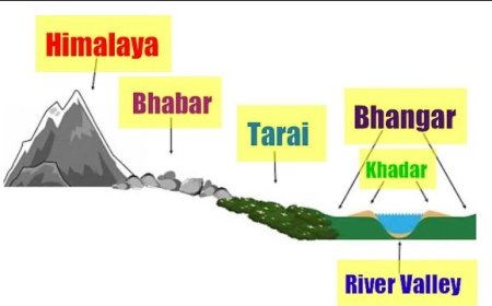
The Bhabar Plain
- Made up of gravels and unassorted sediments deposited by Himalayan rivers.
- High porosity leads to disappearance of small streams.
- Width varies from 8 to 15 km.
- Wider in the western plains (Jammu Division) than in the east (Assam).
- Not suitable for cultivation; only big trees with large roots thrive here.
The Tarai Tract
- Zone characterized by excessive dampness, thick forests, and rich wildlife.
- Lies south of the Bhabar plains.
- Width ranges from 15 to 30 km.
- Wider in the eastern parts of the Great Plains, particularly in the Brahmaputra Valley due to heavy rainfall.
- Many states have cleared Tarai forests for cultivation purposes.
The Bhangar Plains
- Upland alluvial tracts of the Great Plains of India, formed by older alluviums.
- Located above the flood limits of rivers.
- Soil is dark in color, rich in humus content, well-drained, and suitable for agriculture.
The Khadar Plains
- New alluvium tracts formed along the courses of rivers.
- Also known as 'Khadar' or 'Bet' lands.
- Enriched annually by fresh deposits of silt during rainy seasons.
- Consists of sand, silt, clay, and mud.
- Highly fertile soil, suitable for agriculture
Delta
- Triangle-shaped fertile land at the mouth of the Ganga and Brahmaputra rivers, known as the Sundarban delta.
- Largest and fastest-growing delta.
- Area of deposition where the river flows sluggishly.
- Deltaic plain composed mainly of old mud, new mud, and marsh.
- Uplands in the delta region are called 'Chars', while marshy areas are called 'Bils'.
On the basis of deposition of sediments by various rivers and topographical characteristics, the Northern Plains of India is divided into the following four major regions:

Rajasthan Plains
- Located west of the Aravalli range, covering an area of about 1,75,000 sq. km.
- Formed by deposition of the river Luni and the long-vanished river Saraswathi.
- Several salt lakes are present, with Sambhar salt lake (Pushkar Lake) near Jaipur being prominent.
- Thar Desert
- Also known as the Great Indian Desert, it is a large arid region in the northwestern part of the Indian subcontinent.
- Covers an area of 200,000 sq. km, making it the 7th largest desert in the world.
- Lies in the western part of the Aravalli range and covers 2/3 of the Rajasthan state.
- Divided into two major regions: Actual desert region (Marusthali) and semi-desert region (Bhangar).
- Characterized by various types of sand dunes and salt lakes (Dhands).
Punjab - Haryana Plains
- Lies to the northeast of the Great Indian Desert.
- Covers an area of about 1.75 lakh sq. km.
- Formed by deposition of the rivers Sutlej, Beas, and Ravi.
- Acts as a water-divide (doab).
- Divides two major watersheds:
- Yamuna – Sutlej
- Ganga – Yamuna
Ganga Plains
- Extends from the Yamuna River in the west to Bangladesh in the east.
- Total area covered by this plain is about 3.75 lakh sq. km.
- Formed by sediments deposited by the River Ganga and its tributaries such as Ghaghra, Gandak, Kosi, Yamuna, Chambal, Betwa, etc.
- Largest plain in India.
- General slope of the entire plain (upper, middle, and lower Ganga plains) is towards east and southeast.
Brahmaputra Plains
- Located mainly in the state of Assam.
- Low-level plain in the eastern part of the Great Plains of India.
- Formed by deposits of the river Brahmaputra.
- Covers an area of about 56,275 sq. km.
- These plains create alluvial fans and marshy tracts.
What's Your Reaction?