Location-India

Area
- Total: 3.287 million square kilometers
- As a % of world: About 2.4%
Rank as Largest Country
- In the World: 7th largest
- In Asia: 3rd largest, if Russia is included.
Latitude and Longitude Extent
- Latitudinal Extent: 8°4'N to 37°6'N
- Longitudinal Extent: 68°7'E to 97°25'E
- Hemisphere: Northern and Eastern Hemispheres
Extreme Points
- Northernmost Point: Indira Col in the Siachen Glacier (37°6'N)
- Southernmost Point - Mainland: Kanyakumari (8°4'N)
- Southernmost Point - Country: Pygmalion point or Indira Point in the Great Nicobar Island (6°45'N)
- Western most point- West of Guhar Mota in Gujarat
- Eastern most point- Kibithu in Arunachal Pradesh
Dimensions
- East-West Length: Approximately 2,933 km
- North-South Length: Approximately 3,214 km
Tropic of Cancer Passing States
- States: Gujarat, Rajasthan, Madhya Pradesh, Chhattisgarh, Jharkhand, West Bengal, Tripura, and Mizoram
Indian Standard Time (IST)
- Latitude: 82°30'E
- Passing City: Mirzapur near Allahabad (Prayagraj)
- Passing States: Uttar Pradesh
- Difference: 5 hours and 30 minutes ahead of Greenwich Mean Time (GMT+5:30)
- Time difference from GMT: +5:30 hours
Smallest States by Area (Last 5)
- Goa
- Sikkim
- Tripura
- Nagaland
- Mizoram
Largest States by Area (Top 5)
- Rajasthan
- Madhya Pradesh
- Maharashtra
- Uttar Pradesh
- Gujarat
Country - states sharing international boundary
- Pakistan- Jammu Kashmir (UT), Punjab, Rajasthan, Gujrat
- Bangladesh- West Bengal, Assam,Meghalaya, Tripura, Mizoram
- Myanmar - Mizoram, Manipur, Nagaland, Arunanchal Pradesh
- Bhutan- Arunchal Pradesh, Assam, West Bengal, Sikkim
- China- Laddakh (UT), Himachal Pradesh, Sikkim, Uttarakhand, Arunchal Pradesh
- Nepal - Uttarakhand, Uttar Pradesh, Sikkim, West Bengal Bihar
- Afganistan - Laddakh (UT).
Which State does not have an International Border?
There are a total of five states and two union territories of India which do not have an International border that do not lie on the coast. The states are Haryana ,Madhya Pradesh , Jharkhand, Chhattisgarh and Telangana and union territories are Chandigarh and Delhi.
State that shares Boundary with maximum states?
- Uttar Pradesh the only Indian State which has a maximum number of neighbouring states.
- Uttar Pradesh shares a border with Nine states/ Union Territory.
- Northwest - Uttrakhand and Himachal Pradesh.
- West - Haryana, Delhi, and Rajasthan.
- South - Madhya Pradesh.
- East - Jharkhand,Bihar, and Chhattisgarh.
Land Border Length
- Total Land Border Length: Approximately 15,106 km
Coastline
- Coastline on Mainland: Approximately 6100km
- Total Coastline including Islands: Approximately 7,516.6 km
Border Names and Lengths with Adjoining States, Forces
-
Radcliffe Line:
- Awarded by: Sir Cyril Radcliffe
- Bordered States: India and Pakistan
- Length: Approximately 3,323 km
- Forces: Border Security Force (BSF)
-
McMahon Line:
- Awarded by: Sir Henry McMahon
- Bordered States: India and China
- Length: Approximately 1,126 km
- Forces: Indo-Tibetan Border Police (ITBP), Indian Army
-
Durand Line:
- Awarded by: Sir Mortimer Durand
- Bordered States: Pakistan and Afghanistan (India has no direct border, but this is significant for geopolitical reasons)
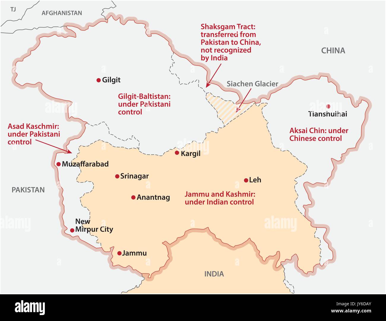
Disputed Areas
-
With China:
- Line of Actual Control (LAC): Unofficial boundary between India and China.
- Areas: Arunachal Pradesh, Aksai Chin.
-
With Pakistan:
- Line of Control (LOC): Military control line between India and Pakistan in the Jammu and Kashmir region.
- Siachen Glacier: Site of conflict since Operation Meghdoot on 13 April 1984.
- Sir Creek: Disputed area between Gujarat (India) and Sindh (Pakistan).
-
Katchatheevu Island:
- Awarded to: Sri Lanka in 1976.
- Location: Palk Strait.
Administrative Divisions
- Initial Divisions: 14 States and 6 Union Territories (UTs)
- Current Divisions: 28 States and 8 Union Territories
Border sharing Table- Country, Distance,States Sharing, Important Border Location, Rivers.
| Country | Distance (km) | Indian States Sharing Border | Important Border Locations | Major Rivers |
| Bangladesh | 4,096 | West Bengal, Assam, Meghalaya, Tripura, Mizoram | Petrapole (West Bengal), Dawki (Meghalaya), Akhaura (Tripura) |
Ganges (Padma), Brahmaputra (Jamuna), Teesta, Feni
|
| China | 3,488 | Jammu and Kashmir, Ladakh, Himachal Pradesh, Uttarakhand, Sikkim, Arunachal Pradesh | Nathu La (Sikkim), Demchok (Ladakh), Lipulekh (Uttarakhand) |
Brahmaputra (Yarlung Tsangpo), Indus, Sutlej
|
| Pakistan | 3,323 | Punjab, Rajasthan, Gujarat, Jammu and Kashmir, Ladakh | Wagah (Punjab), Munabao (Rajasthan), Uri (Jammu and Kashmir) |
Indus, Sutlej, Ravi, Beas, Chenab
|
| Nepal | 1,751 | Uttarakhand, Uttar Pradesh, Bihar, West Bengal, Sikkim | Raxaul (Bihar), Banbasa (Uttarakhand), Panitanki (West Bengal) |
Ganges, Gandak, Kosi, Mahakali
|
| Myanmar | 1,643 | Arunachal Pradesh, Nagaland, Manipur, Mizoram | Moreh (Manipur), Zokhawthar (Mizoram), Nampong (Arunachal Pradesh) |
Chindwin, Kaladan, Naf
|
| Bhutan | 699 | Sikkim, West Bengal, Assam, Arunachal Pradesh | Jaigaon (West Bengal), Gelephu (Assam), Samdrup Jongkhar (Assam) |
Manas, Sankosh, Torsa, Jaldhaka
|
| Afghanistan | 106 | Jammu and Kashmir (disputed region) | Wakhan Corridor (Jammu and Kashmir) |
None (landlocked border area)
|
States Formation Order
|
Dhar Commission- Linguistic Province Commission |
1948 |
Based on Admin convenience |
|
JVP-Linguistic Province Commission |
1948 |
Rejected Language as Basis |
|
Andhra Pradesh |
October 1953 |
Potti Sriramlu -56 Hunger Strike |
|
Fazl Ali- State Reorganisation Commission |
1953, Report 1956 |
SRC Act 1956 and 7th Amendment act Formed 14 states and 6 Union territories |
|
1960 |
Gujarat |
|
|
1961 |
Dadra and Naga Haveli |
10th CA as UT |
|
1961 |
Daman and Diu, Goa |
12th CA as UT |
|
1962 |
Pondicherry |
14th CA as UT |
|
1963 |
Nagaland |
|
|
1966 |
Haryana, Chandigarh |
|
|
1971 |
Himachal Pradesh |
|
|
1972 |
Manipur, tripura and Meghalaya |
|
|
1975 |
Sikkim |
36th CA, 371F Special Provision |
|
1987 |
Mizoram, Arunachal Pradesh, Goa |
|
|
2000 |
Chattisgarh, Uttarakhand, Jharakand |
|
|
2014 |
Telangana |
|
|
2019 |
J K as UT |
Presidential Order 2019 |


What's Your Reaction?